Search
Items tagged with: Sentinel2
https://youtu.be/NwL2f5Nrn3U

Downloading free satellite images using the Semi-Automatic Classification Plugin
Downloading free satellite images using the Semi-Automatic Classification Plugin: the Download product tabSCP Websitehttps://fromgistors.blogspot.com/p/semi-...YouTube

https://www.mundialis.de/en/satellite-image-of-the-month-october-almeria/
made with #OSGeo
#Sentinel2 #Copernicus #satelliteimageofthemonth #Almería #ElEjido #mardeplastico #opendata #opensource

Satellite image of the month - October - Almería (Spain) — mundialis
Our satellite image of the month October shows a section of the Spanish south coast, in the province of Almería in Andalusia.Julia Haas (mundialis GmbH & Co. KG)
https://r.iresmi.net/posts/2023/copernicus_openeo_ndvi_time_series/
#RemoteSensing #Sentinel2 #rspatial
 at 0.35; the deciduous forest shows the alternating seasons between 0.6 and 0.8; the corn fields shows the growing seasons until the harvest from 0.2 to 0.8.")
r.iresmi.net - Copernicus OpenEO NDVI time series
Use the OpenEO API to access Copernicus satellite datasetsr.iresmi.net


This new version will improve the capabilities of Semi-Automatic Classification Plugin, based on a completely new #python processing framework that is Remotior Sensus, developed for image classification such as #landsat #sentinel2 , #machinelearning and #gis spatial analyses.
https://fromgistors.blogspot.com/2023/07/Semi-AutomaticClassificationPluginReleaseDate.html
Semi-Automatic Classification Plugin v.8 Release Date
A blog that goes from GIS to Remote Sensing, tutorials for open source software, Land Cover, and the Semi-Automatic Classification Plugin for QGIS.fromgistors.blogspot.com
#Sentinel2 #Copernicus #satelliteimageofthemonth #Sudan #NorthernAfrica #GeziraScheme
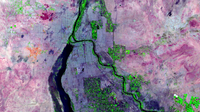
Satellite image of the month - April - Khartoum (Sudan) — mundialis — free data with free software
Khartoum – Sudan, recorded by the Sentinel-2A satellite on May 17, 2021 Our satellite image of the month April shows the city of Khartoum and its surroundings.Julia Haas (mundialis GmbH & Co. KG)
A new eruptive episode started at the #Mexican🇲🇽 volcano around two weeks ago. Thankfully no evacuations were necessary
Authorities have, in the meantime, lowered the alert level 🌋
🐦🔗: https://n.respublicae.eu/CopernicusEU/status/1667821017819906049


