Search
Items tagged with: NASA
C'è più spazio intorno a noi di quanto si creda!
")
Grazie per l'ascolto! 🙏👋🚀
Credito immagine: NASA.


On Sol 1037 (three days ago) the Perseverance rover observerved this transit of Mars' smallest moon Deimos.
This timelapse shows the event at 10x speed.
Credit: NASA/JPL-Caltech/ASU/Simeon Schmauß
#Mars #NASA #Perseverance #Deimos #Transit #Sun #Solarocks
Deimos transit - Perseverance Sol 1037
This sequence was upscaled 2x using the Enhance function in Adobe Lightroom. The sequence lasted 137 seconds in reality and is shown at 10x speed. Credit: NASA/JPL-Caltech/ASU/Simeon SchmaußFlickr
Bisogna avere sempre lo SPIRIT giusto
https://edu.inaf.it/rubriche/risate-spaziali/bisogna-avere-sempre-lo-spirit-giusto/
Indietro come i gamberi
#Marte #NASA #Spirit #vignetta

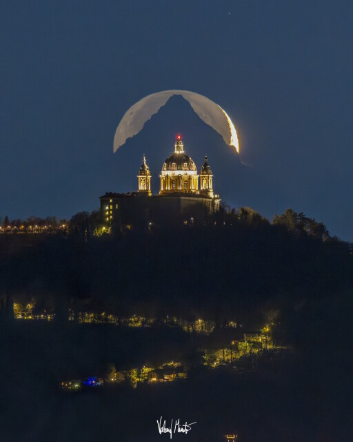
La Basilica di Superga, il Monviso, la Luna con la luce cinerea: uno scatto perfetto e meraviglioso di Valerio Minato pH premiato dalla #NASA
Anticipo i denigratori seriali sempre presenti sui social network: questa foto NON è un fotomontaggio! Non siate invidiosi e godetevi lo spettacolo...
Italians do It Better!
“Mai come nello spazio ti accorgi che i confini non esistono. Dall'alto l'Europa é un reticolo di luci, collegamenti, i cui confini sono solo dentro le menti delle persone.”
Luca Parmitano ✨
.
#spazio #primafrontiera #lucaparmitano #cosmonauta #russia #astronauta #america #nasa #esa #isa #usa

With the mars rovers sending no data due to solar conjunction I finally get to catch up with processing some old, but spectacular images!
Credit: NASA/JPL-Caltech/Simeon Schmauß
#Mars #NASA #Perseverance #Solarocks

5 quickly processed, undistorted HELI_RTE images played at 2 fps
Sol: 915, RMC: 59.0001, LMST: 11:06:39
One of the originals: https://mars.nasa.gov/mars2020-raw-images/pub/ods/surface/sol/00915/ids/edr/browse/heli/HSF_0915_0748163972_664ECM_N0590001HELI00004_000085J01.png
Credit: #NASA/JPL-Caltech/65dBnoise
#MarsHelicopter #Perseverance #Mars2020 #Solarocks #Space

-updated tool for downloading #NASA Harmonized #Landsat and #Sentinel-2 images, as well as #Copernicus Sentinel-2 images.
-unified interface for preprocessing #remotesensing images
-updated classification tool including #machinelearning algorithms: Multi-Layer Perceptron, Support Vector Machine, and Random Forest through #scikitlearn and #PyTorch
https://fromgistors.blogspot.com/2023/09/road-to-semi-automatic-classification-images-classification.html

Road to the Semi-Automatic Classification Plugin v.8: Landsat and Sentinel-2 images download and preprocessing, classification
A blog that goes from GIS to Remote Sensing, tutorials for open source software, Land Cover, and the Semi-Automatic Classification Plugin for QGIS.fromgistors.blogspot.com
People in #gischat #EarthObservation and #RemoteSensing what are the best satellite products to follow smoke likes this besides the above. Aerosol depth perhaps?
