Search
Items tagged with: blender
Il #7novembre esce in sala #Flow . Presentato alla Festa del #cinema di #Roma, è un gioiello a basso costo, realizzato con software #opensource .
https://www.wired.it/article/flow-un-mondo-da-salvare-film-animazione-trama-uscita-recensione/

Flow, il nuovo film d'animazione realizzato con tecniche da videogioco è straordinario
Ece in sala il 7 Novembre ed è stato presentato alla Festa del cinema di Roma, è un gioiello a basso costo, realizzato con software open source e un motore grafico simile all'Unreal EngineGabriele Niola (Wired Italia)

☝️ We are starting in one hour with
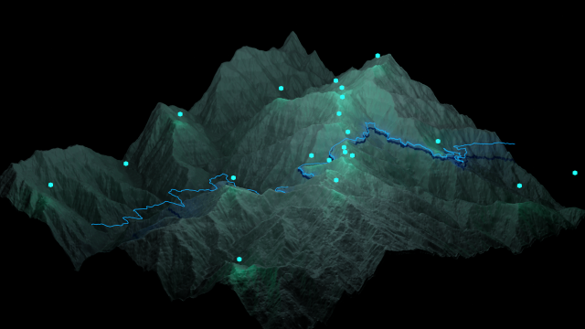
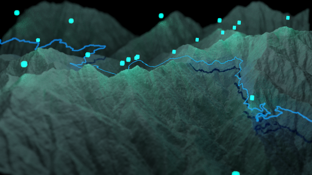
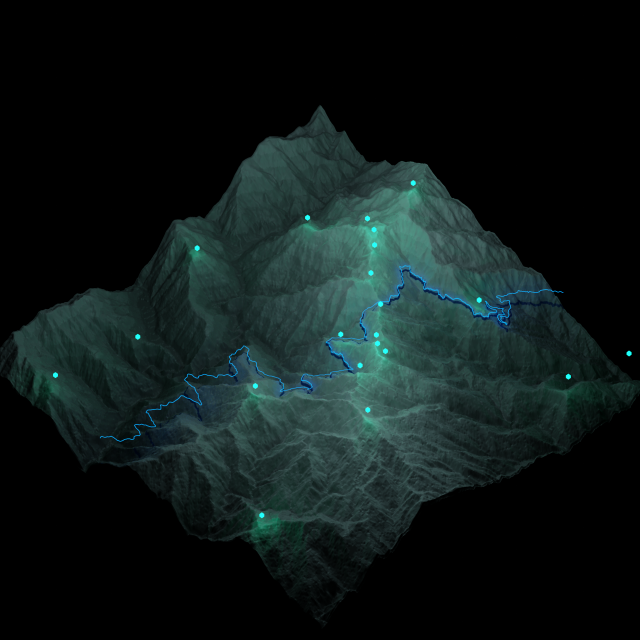
"How to Make a Beautiful #3D Georeferenced #Map using #QGIS and #Blender" by Hemed Lungo
followed by
"QGIS Plugin AIAMAS - #AI-Assisted Map Styler" by @sfkeller
#GISChat #Mapping #Geospatial #QOD #QGISOpenDay #AIAssisted #AIAssistedMap
For those who can't afford commercial software, and for those who want full flexibility and extensibility and future-proofing the ability to open their own art work years from now, there's free open source software:
* #Krita: replaces Adobe Photoshop for editing and painting; https://krita.org/
* #Inkscape: multi-page, replaces Adobe Illustrator and Adobe InDesign; great for scientific figures and posters; https://inkscape.org/
* #Gimp: image editor, with layers and transparencies; replaces Adobe Photoshop; https://www.gimp.org/
* #MyPaint: just for painting; https://mypaint.app/
* #FijiSc: for image processing and image analysis, with conventional computer vision techniques and also machine learning. Handles multi-dimensional bioimagery. https://fiji.sc
* #Blender: for 3D animation and video editing; https://blender.org
* #ffmpeg: command-line based video editing; see this page https://ffmpeg.lav.io/ for testing out commands.
I don't use anything else: there's no need. And all of the above are extensively documented.

Draw Freely | Inkscape
Inkscape is professional quality vector graphics software which runs on Linux, Mac OS X and Windows desktop computers.inkscape.org
Blender 4.0 - Reel
See everything new in Blender 4.0 LTS https://www.blender.org/download/releases/4-0/
Support Blender development: https://fund.blender.org
#blender #b3d #peertube
Credits:
8x642
Akelex One
Alexander West
Andre Laham
Andres Stephens
Andry Rasoahaingo
ARA Studios
BANNO Yuki
do_it_Iker
ina__
Jace Kunfermann
KOALA OK
L3Dart
Lorenzo Aiello
maxhayart
NegativeVibrat1
reiya_mof
Roya Baradaran Rahmanian
Rui Huang
savannahXYZ
Sturm Studio
Teeteegone
vehgeto
WINGYTQ
Yasemin Koyuncu
Music: Mariana Calegari
--
Follow Blender:
* Twitter: https://twitter.com/blender
* Instagram: https://instagram.com/blender.official
* Facebook: https://facebook.com/YourOwn3DSoftware
* TikTok: https://www.tiktok.com/@blender_org
* Mastodon: https://mastodon.social/@blender
--
Follow Blender Development:
* Blog: https://code.blender.org
* Twitter: https://twitter.com/BlenderDev
Blender (@blender_org) | TikTok
Blender (@blender_org) on TikTok | 4.7K Likes. 2.3K Followers. Official account for the Free and Open Source 3D creation suite. ❤️ #b3d.Watch the latest video from Blender (@blender_org).Blender (TikTok)
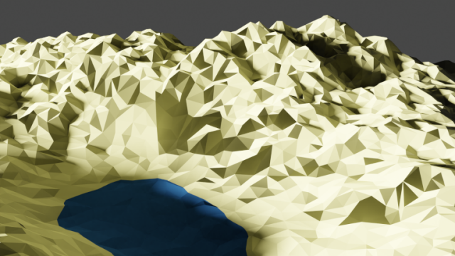
Interested in making these sorts of images, check out my tutorial - https://youtu.be/PFKnCzMoQbc?si=yLUKXr479h8GhgHK


Creating Textured 3D Terrains with QGIS and Blender
Open Source Digital Heritage is a new tutorial series introducing the use of various open source software as used by the heritage industry. These lessons wil...YouTube


Here is a recipe for a slope raster, or at least an approximation. Like the #qgis equivalent, brighter areas are steeper terrain.
Send normal pass into Normal node to get dot product, normalize it, tweak gamma and invert. Probably need to tweak the gamma for each surface.
Should also work in shader node editor, the nodes are all there too.