Search
Items tagged with: maps
Climate analogues project strong regional differences in the future water and electricity demand across US cities (2023): https://www.cell.com/one-earth/fulltext/S2590-3322(23)00454-2 @climate
#analogs #analogues #climateChange #climate #projections #dataViz #map #maps #classification #USA #DC #LA #SF #SFBA #Chicago #Portland #Seattle #Dallas


Neat maps of #AsianFood in the US from Pew Research Center:
via FlowingData newsletter (Nathan Yau) and Pew study authors Sono Shah and Regina Widjaya (none of whom are on Mastodon)
#DataViz #Cartography #maps #visualization

Most Asian restaurants serve Chinese, Japanese or Thai food in the US | Pew Research Center
In the U.S., 12% of all restaurants serve Asian food; that share is slightly higher than the 7% of the U.S. population that is Asian American.Pew Research Center
Reached the end of the line with your #GeoPandas plots? Replace them with maps rendered by QGIS.
http://anitagraser.com/2023/11/10/bringing-qgis-maps-into-jupyter-notebooks/
#maps #GISChat #DataScience #SpatialDataScience #DataViz #GIS

Bringing QGIS maps into Jupyter notebooks
Earlier this year, we explored how to use PyQGIS in Juypter notebooks to run QGIS Processing tools from a notebook and visualize the Processing results using GeoPandas plots. Today, we’ll go …Free and Open Source GIS Ramblings
https://explorer.audubon.org/explore/species/1527/american-coot/migration
#ornithology #dataviz #maps

American Coot - Migration Map | Bird Migration Explorer
See where the American Coot travels throughout the hemisphere each year.explorer.audubon.org
Anyway, here's my bad map titled 'All the Scots in Scotland' which shows all places with 'scot' in their name. And yes, I have used Irn Bru colours, what's your problem? 😉
Data came from #OpenStreetMap Made in #QGIS and #inkscape
#Scotland #maps #irnbru
")
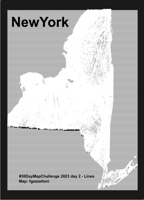
NewYork data from USDA NRCS Geospatial Data Gateway. Made with {topo.ridges} packages
Tools: #R
#rstats #datascience #Datavisualization #maps #infographics
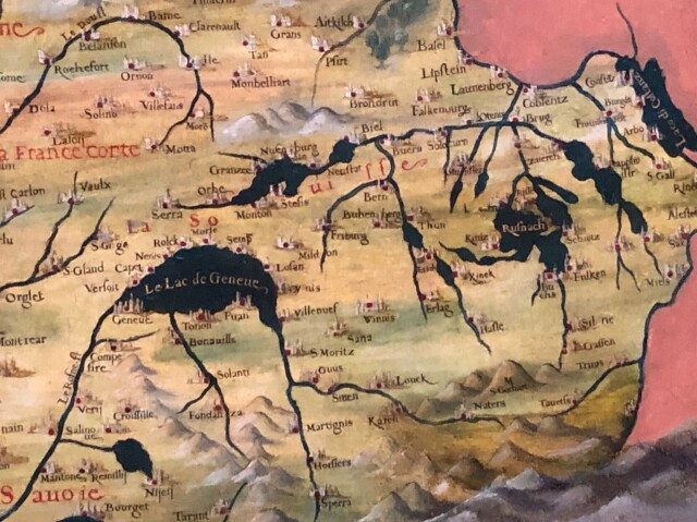
You can spot the Geneva lake among others.
The "Hall of Geographical #Maps" represent the world as it was known in the mid-16th century.
South Up Equal Earth Projection in R
Yup - I'm still banging on about this! This time, in R
Result
The colours are wrong, and the labels need adjustment - but not bad for a few lines of code!
Code
library(tidyverse)
library(rnaturalearth)
library(rnaturalearthdata)
library(sf)
centre
https://shkspr.mobi/blog/2021/07/south-up-equal-earth-projection-in-r/

Holy shit I think I’m in love.
#Protomaps, a way to serve vector #maps of the entire world using a single static file and HTTP range requests.
It’s basically a static site generator for interactive maps. Tile servers are pretty much obsolete now. No database needed, you can run your interactive, smooth-zooming vector map from any HTTP storage. S3, Caddy running on your Wi-Fi router, even GitHub pages.
It’s open source & free to use. Wow. 🤯
via https://chaos.social/@djh/111280447304607540
A free and open source map of the world
Protomaps is an alternative to Map APIs that you run on your own cloud storage.protomaps.com