Search
Items tagged with: mapping
☝️ We are starting in one hour with
"How to Make a Beautiful #3D Georeferenced #Map using #QGIS and #Blender" by Hemed Lungo
followed by
"QGIS Plugin AIAMAS - #AI-Assisted Map Styler" by @sfkeller
#GISChat #Mapping #Geospatial #QOD #QGISOpenDay #AIAssisted #AIAssistedMap

--
https://www.nature.com/articles/s41598-023-42696-9 <-- shared paper
--
#GIS #spatial #mapping #remotesensing #InSAR #radar #deformation #NewMexico #aquifer #groundwater #waterresources #numericmodeling #model #modeling #injection #well #injectionwell #oilandgas #risk #hazard #grounddeformation #inducedseismicity #seismicity #surfacedeformation #waterresources #waterquality #watersecurity #water #hydrology
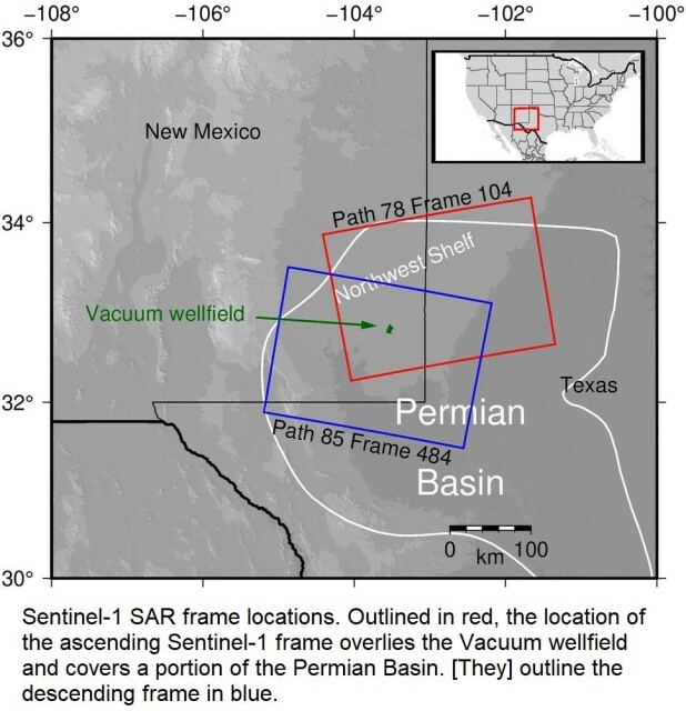

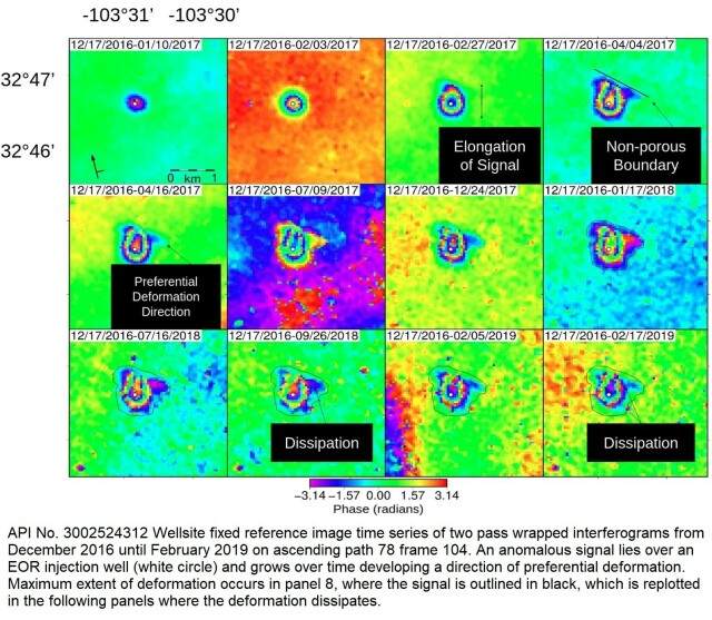
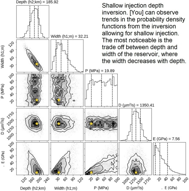
InSAR-observed surface deformation in New Mexico’s Permian Basin shows threats and opportunities presented by leaky injection wells - Scientific Reports
Scientific Reports - InSAR-observed surface deformation in New Mexico’s Permian Basin shows threats and opportunities presented by leaky injection wellsNature
https://youtu.be/EHWCJRapWCE?si=Gpfm-1aBKfJ0BMcX
#gischat #maps #mapping

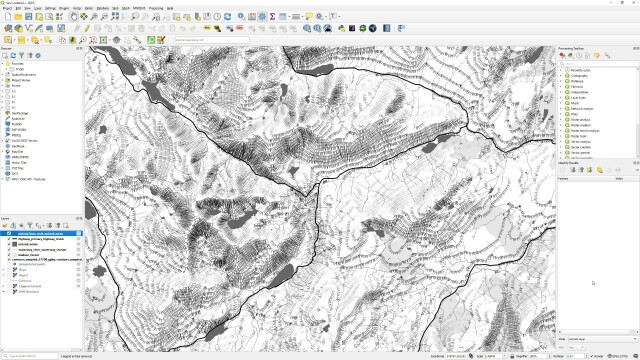
QGIS User 0051 - Open Polygon Style
I made a style in the QGIS Hub that I explain how to use in this video.The style draws outlines but not ends for polygons drawn according to some rules. You ...YouTube
--
https://www.youtube.com/@automaticknowledge/videos <-- links to a large variety of tutorial videos
--
“Short, straight-to-the-point videos about how to do things in QGIS (the world's most popular GIS software) - plus a few longer tutorials, and maybe other related software occasionally. [The author has] put these together in the hope that they save someone a little bit of time, energy and frustration!...”
#GIS #spatial #mapping #opensource #QGIS #training #onlinetraining #selflearning #freetraining #videotutorial #ongoingeducation #continuingeducation #continuouslearning #gischat #GISsoftware #education #learningopportunity
@qgis

Map Academy
Short, straight-to-the-point videos about how to do things in QGIS (the world's most popular GIS software) - plus a few longer tutorials, and other map-related software occasionally.YouTube


--
https://doi.org/10.3390/rs14184484 <-- shared paper
--
#GIS #spatial #mapping #satellitederivedbathymetry #SDB #nauticalcharting #machinelearning #IHOstandards #GEBCO #Seabed2030 #radiativetransferequation #RTE #remotesensing #satellite #model #modeling #hydrography #hydrospatial #marine #charts #navigation #nautical #gischat #bathymetry #topobathy #automation #ESA
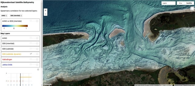
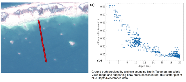
A New Approach to Satellite-Derived Bathymetry: An Exercise in Seabed 2030 Coastal Surveys
ARGANS has years of experience in analysing the factors limiting light transmission in coastal environments around the world.MDPI
Check out @foss4g's channel https://youtube.com/@FOSS4G if you want to catch up with the latest #opensource #gis developments
#gischat #geospatial #mapping #maps

--
https://github.com/unvt/portable
--
" ‘UNVT Portable’ is a package for RaspberryPi that functions as a map hosting server and can be freely accessed from a web browser within a local network.
It is mainly intended to function in an offline environment during times of severe disaster, and is expected to play an active role... where disaster response headquarters are set up to assess the situation and respond to disasters by combining aerial drone images taken after a disaster occurs with OpenStreetMap and various open data tile data sets prepared in advance…”
#GIS #spatial #mapping #gischat #portable #mapserver #raspberrypi #raspberry #hosting #server #webbrowser #localnetwork #onsite #disasterresponse #hardware #solution #opensource #openformat #responsecenter #disasterresponsecenter #headquarters #readyresponse #mobile #mobileoffice #emergencyresponse #emergencymanagement #emergencypreparedness #risk #hazard #onlinemapping

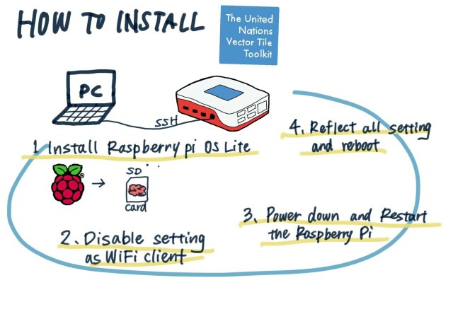
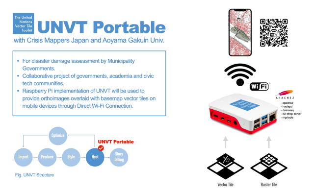
GitHub - unvt/portable: UNVT Portable
UNVT Portable. Contribute to unvt/portable development by creating an account on GitHub.GitHub
Visualisation of all civil flights over #Ireland on 22th of May 2018 from 00-24h by #Flickr user neboysh
- Data source:
#ARTAS (Air traffic management surveillance tracker and server), 4002 unique #flights extracted from 3 million #GPS tracking points
- Software: #QGIS 3.2.1
https://flickr.com/photos/10169636@N07/42565210515/in/pool-qgis/
#Dataviz #mapping #gischat #aviation #MobilityAnalytics #MovementDataAnalytics

Visualisation of all civil flights over Ireland on 22th of May 2018 from 00-24h
- Data source: ARTAS (Air traffic management surveillance tracker and server), 4002 unique flights extracted from 3 million GPS tracking points - Software: QGIS 3.2.1Flickr
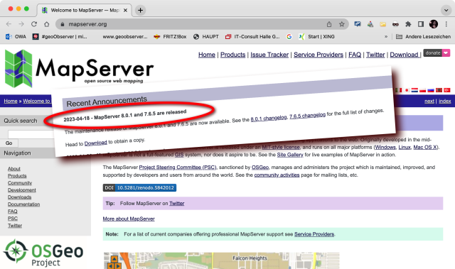
Updated: Mapserver 8.0.1
Screentshot: Ankündigung MapServer 8.0.1 (Quelle [1]) Oops, ich bin wohl etwas spät? Schon im April wurde auf mapserver.org [1], [2] mitgeteilt, dass der beliebte MapServer in der Ve…#geoObserver