Search
Items tagged with: InSAR
InSAR-Observed Surface Deformation In New Mexico’s Permian Basin Shows Threats And Opportunities Presented By Leaky Injection Wells [remote sensing]
--
https://www.nature.com/articles/s41598-023-42696-9 <-- shared paper
--
#GIS #spatial #mapping #remotesensing #InSAR #radar #deformation #NewMexico #aquifer #groundwater #waterresources #numericmodeling #model #modeling #injection #well #injectionwell #oilandgas #risk #hazard #grounddeformation #inducedseismicity #seismicity #surfacedeformation #waterresources #waterquality #watersecurity #water #hydrology
--
https://www.nature.com/articles/s41598-023-42696-9 <-- shared paper
--
#GIS #spatial #mapping #remotesensing #InSAR #radar #deformation #NewMexico #aquifer #groundwater #waterresources #numericmodeling #model #modeling #injection #well #injectionwell #oilandgas #risk #hazard #grounddeformation #inducedseismicity #seismicity #surfacedeformation #waterresources #waterquality #watersecurity #water #hydrology
InSAR-observed surface deformation in New Mexico’s Permian Basin shows threats and opportunities presented by leaky injection wells - Scientific Reports
Scientific Reports - InSAR-observed surface deformation in New Mexico’s Permian Basin shows threats and opportunities presented by leaky injection wellsNature
I thought it might be interesting for some of the #gischat members of Mastodon to share some of my everyday map making. A thread with a single map and some info on the data, techniques, tips, and tricks. Let's go!
Daily #mapmaking with #qgis
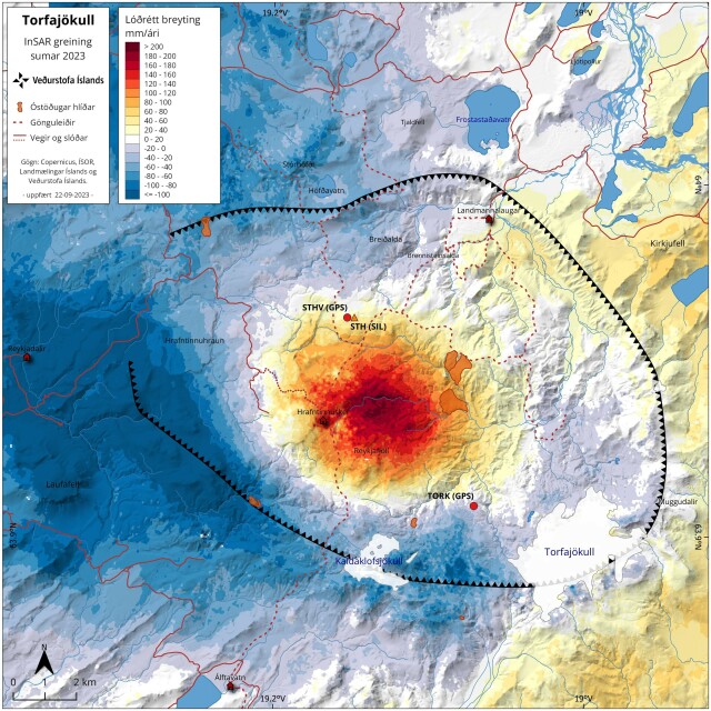
This map shows a recent #InSAR analysis for a volcanic caldera named Torfajökull. The InSAR signal shows there is surface inflation in the center of the volcanic caldera indicating sub-surface magma movement.
🧵 1/10
Daily #mapmaking with #qgis
This map shows a recent #InSAR analysis for a volcanic caldera named Torfajökull. The InSAR signal shows there is surface inflation in the center of the volcanic caldera indicating sub-surface magma movement.
🧵 1/10
