Search
Items tagged with: water
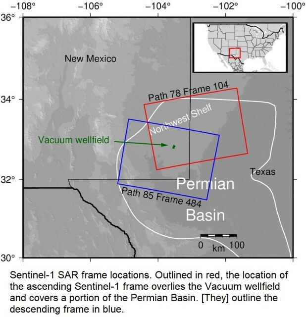
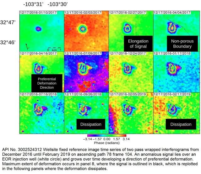
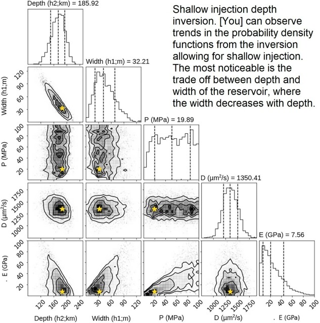
InSAR-Observed Surface Deformation In New Mexico’s Permian Basin Shows Threats And Opportunities Presented By Leaky Injection Wells [remote sensing]
--
https://www.nature.com/articles/s41598-023-42696-9 <-- shared paper
--
#GIS #spatial #mapping #remotesensing #InSAR #radar #deformation #NewMexico #aquifer #groundwater #waterresources #numericmodeling #model #modeling #injection #well #injectionwell #oilandgas #risk #hazard #grounddeformation #inducedseismicity #seismicity #surfacedeformation #waterresources #waterquality #watersecurity #water #hydrology
--
https://www.nature.com/articles/s41598-023-42696-9 <-- shared paper
--
#GIS #spatial #mapping #remotesensing #InSAR #radar #deformation #NewMexico #aquifer #groundwater #waterresources #numericmodeling #model #modeling #injection #well #injectionwell #oilandgas #risk #hazard #grounddeformation #inducedseismicity #seismicity #surfacedeformation #waterresources #waterquality #watersecurity #water #hydrology
InSAR-observed surface deformation in New Mexico’s Permian Basin shows threats and opportunities presented by leaky injection wells - Scientific Reports
Scientific Reports - InSAR-observed surface deformation in New Mexico’s Permian Basin shows threats and opportunities presented by leaky injection wellsNature

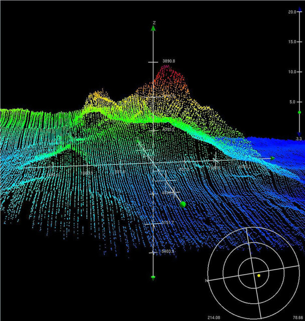
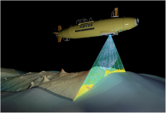
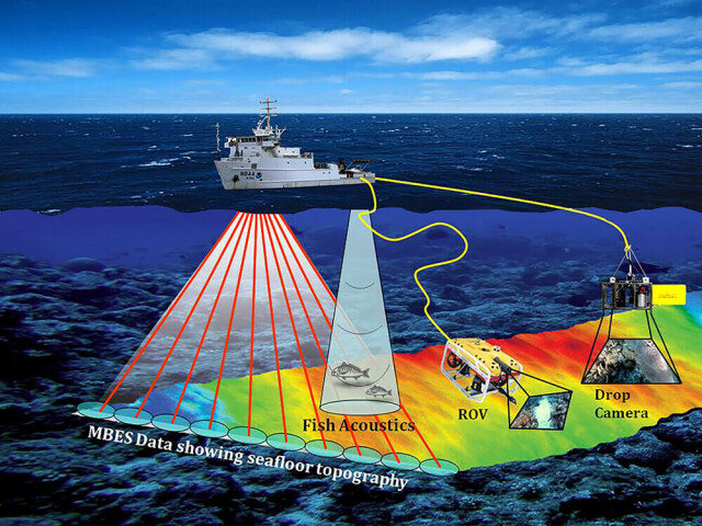
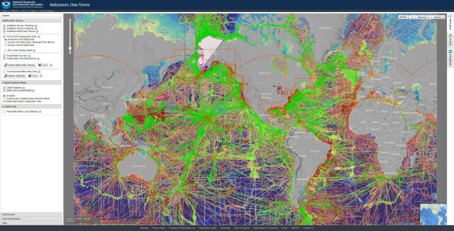
Bathymetric Data Viewer [global, NOAA]
--
https://www.ncei.noaa.gov/maps/bathymetry/ <-- spatial open data web portal
--
“NCEI and the IHO Data Center for Digital Bathymetry (DCDB) archive and share depth data acquired by hydrographic, oceanographic, and industry vessels and platforms during surveys or while on passage. These data, which are used in several national and international mapping bathymetry projects, are free to the public with no restrictions…”
#GIS #spatial #mapping #remotesensing #bathmetry #global #opendata #openaccess #download #NCEI #DCBD #NOAA #elevation #sonar #water #hydrography #hydrospatial #webportal #science #spatialanalysis #DEM #data #digital #multibeam #survey #visualisation #BAG #raster #GEBCO #GMRT #IBSCO #GSHHG
@NOAA @NCEI @GEBCO
--
https://www.ncei.noaa.gov/maps/bathymetry/ <-- spatial open data web portal
--
“NCEI and the IHO Data Center for Digital Bathymetry (DCDB) archive and share depth data acquired by hydrographic, oceanographic, and industry vessels and platforms during surveys or while on passage. These data, which are used in several national and international mapping bathymetry projects, are free to the public with no restrictions…”
#GIS #spatial #mapping #remotesensing #bathmetry #global #opendata #openaccess #download #NCEI #DCBD #NOAA #elevation #sonar #water #hydrography #hydrospatial #webportal #science #spatialanalysis #DEM #data #digital #multibeam #survey #visualisation #BAG #raster #GEBCO #GMRT #IBSCO #GSHHG
@NOAA @NCEI @GEBCO