Search
Items tagged with: flickr
Addendum: to download images from #Flickr, keep in mind it's only a web page, and therefore all its elements will be accessible.
1. Open the page in #Firefox: https://www.flickr.com/photos/artour_a/504052852/in/album-72157603542118616/
2. Push 'F12' to open the developer tools and select the "Images" tab.
3. Shift-click on the reload button at the top left, then notice how the "Images" tab now shows a table with entries.
4. Right-click on the top entry and choose "Save as".
4B. Alternatively, notice the GET to the right, under "Headers", with the direct URL to the image https://live.staticflickr.com/194/504052852_7b61768e16_c.jpg If you copy and paste that into a new browser tab, you'll be able to right-click and copy it or save it as normal.
Remember to always credit the source of your images.
"Bolognese caterpillar" of a moth (Megalopyge sp) from Ecuador
a caterpillar of a megalopygid moth, Megalopyge spFlickr
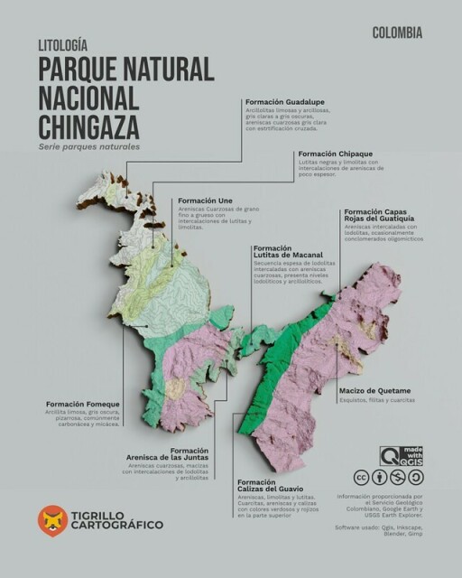
Beautiful #Litology of #Chingaza #NaturalPark #map
by Andrés Felipe Lancheros Sánchez
published in the #QGIS map #showcase #Flickr group:
https://flickr.com/photos/189535481@N03/52426507463/in/pool-qgis/
Don't forget to check out their other work as well 🤩
#qgis #gismaps #qgismaps #maps #cartography #gischat #inkscape #blender #gimp
by Andrés Felipe Lancheros Sánchez
published in the #QGIS map #showcase #Flickr group:
https://flickr.com/photos/189535481@N03/52426507463/in/pool-qgis/
Don't forget to check out their other work as well 🤩
#qgis #gismaps #qgismaps #maps #cartography #gischat #inkscape #blender #gimp
Very interesting ✈️ patterns here:
Visualisation of all civil flights over #Ireland on 22th of May 2018 from 00-24h by #Flickr user neboysh
- Data source:
#ARTAS (Air traffic management surveillance tracker and server), 4002 unique #flights extracted from 3 million #GPS tracking points
- Software: #QGIS 3.2.1
https://flickr.com/photos/10169636@N07/42565210515/in/pool-qgis/
#Dataviz #mapping #gischat #aviation #MobilityAnalytics #MovementDataAnalytics
Visualisation of all civil flights over Ireland on 22th of May 2018 from 00-24h
- Data source: ARTAS (Air traffic management surveillance tracker and server), 4002 unique flights extracted from 3 million GPS tracking points - Software: QGIS 3.2.1Flickr


