Search
Items tagged with: survey
Tomorrow at the University of Guanajuato, within the "Engineering Week" event, I will be presenting, as part of the Official QGIS Mexico User Group  , the #GIS
  of the Government of #Guadalajara 🇲🇽 done in the last two years of work (Only the new developments)
Using #FOSS geospatial
#QGIS #Potree #PostGIS #Geoserver #Leaflet #OpenDroneMap #WebODM #WhiteboxTools #Lastools #CloudCompare #GeoSAM
For #LiDAR #webmapping #drones #photogrammetry #cadastral #survey #AI #mobility
, the #GIS of the Government of #Guadalajara 🇲🇽 done in the last two years of work (Only the new developments)Using #FOSS geospatial
#QGIS #Potree #PostGIS #Geoserver #Leaflet #OpenDroneMap #WebODM #WhiteboxTools #Lastools #CloudCompare #GeoSAM
For #LiDAR #webmapping #drones #photogrammetry #cadastral #survey #AI #mobility

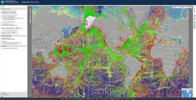
Bathymetric Data Viewer [global, NOAA]
--
https://www.ncei.noaa.gov/maps/bathymetry/ <-- spatial open data web portal
--
“NCEI and the IHO Data Center for Digital Bathymetry (DCDB) archive and share depth data acquired by hydrographic, oceanographic, and industry vessels and platforms during surveys or while on passage. These data, which are used in several national and international mapping bathymetry projects, are free to the public with no restrictions…”
#GIS #spatial #mapping #remotesensing #bathmetry #global #opendata #openaccess #download #NCEI #DCBD #NOAA #elevation #sonar #water #hydrography #hydrospatial #webportal #science #spatialanalysis #DEM #data #digital #multibeam #survey #visualisation #BAG #raster #GEBCO #GMRT #IBSCO #GSHHG
@NOAA @NCEI @GEBCO
--
https://www.ncei.noaa.gov/maps/bathymetry/ <-- spatial open data web portal
--
“NCEI and the IHO Data Center for Digital Bathymetry (DCDB) archive and share depth data acquired by hydrographic, oceanographic, and industry vessels and platforms during surveys or while on passage. These data, which are used in several national and international mapping bathymetry projects, are free to the public with no restrictions…”
#GIS #spatial #mapping #remotesensing #bathmetry #global #opendata #openaccess #download #NCEI #DCBD #NOAA #elevation #sonar #water #hydrography #hydrospatial #webportal #science #spatialanalysis #DEM #data #digital #multibeam #survey #visualisation #BAG #raster #GEBCO #GMRT #IBSCO #GSHHG
@NOAA @NCEI @GEBCO
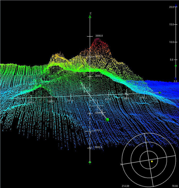
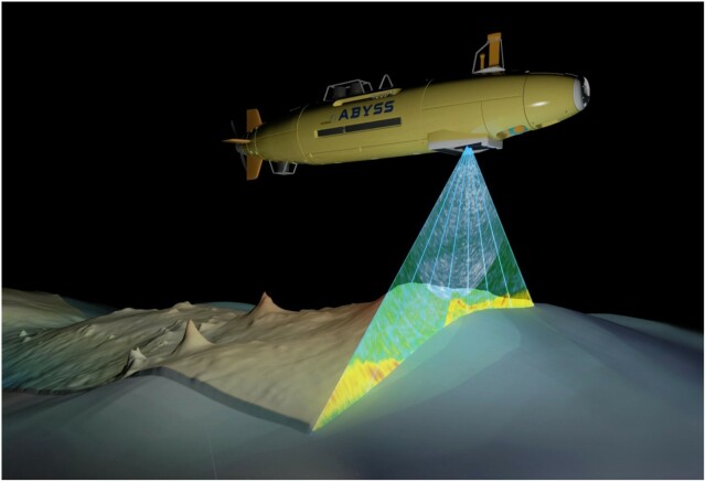
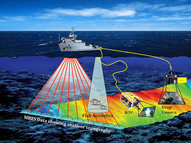
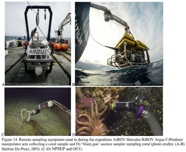
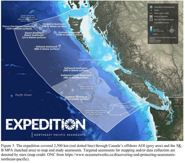
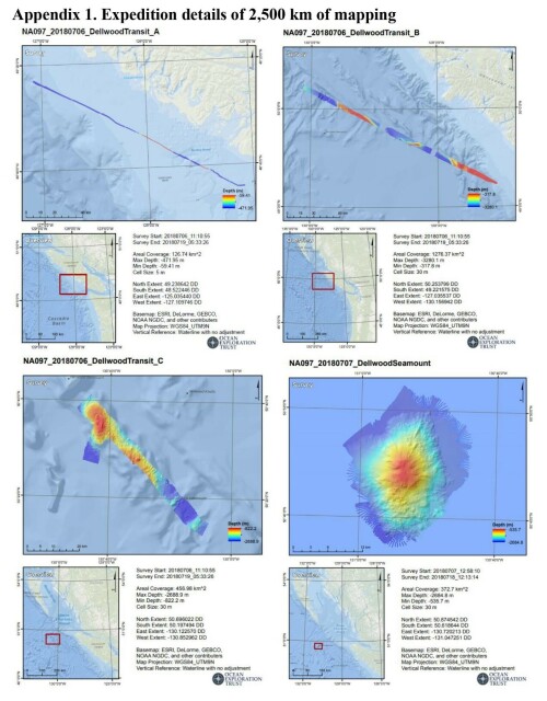
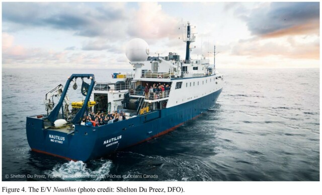
Pacific Seamounts 2018 Expedition Report [British Columbia, Canada]
--
https://publications.gc.ca/collections/collection_2022/mpo-dfo/Fs97-6-3460-eng.pdf <-- their shared report as a PDF
--
[Tang.ɢwan – ḥačxwiqak – Tsig̱is Area of Interest (TḥT AOI)]
#environmental #marine #mining #data #management #environment #biodiversity #canada #offshore #GIS #spatial #mapping #remotesensing #sonar #bathymetry #bathymetric #britishcolumbia #seafloor #seamounts #HaidaNation #NPSEP #ocean #oceanconservation #oceanography #survey #expedition #research #rov #underwater
Fisheries and Oceans Canada
--
https://publications.gc.ca/collections/collection_2022/mpo-dfo/Fs97-6-3460-eng.pdf <-- their shared report as a PDF
--
[Tang.ɢwan – ḥačxwiqak – Tsig̱is Area of Interest (TḥT AOI)]
#environmental #marine #mining #data #management #environment #biodiversity #canada #offshore #GIS #spatial #mapping #remotesensing #sonar #bathymetry #bathymetric #britishcolumbia #seafloor #seamounts #HaidaNation #NPSEP #ocean #oceanconservation #oceanography #survey #expedition #research #rov #underwater
Fisheries and Oceans Canada
As someone who games for entertainment, I found the obvious bias in this research survey to be a bit galling, but feel free to respond and show that games are no different from a lot of forms of entertainment.
https://habs.uq.edu.au/research/volunteer-research-study/video-gamers%E2%80%99-experiences
#gaming #games #survey #research
https://habs.uq.edu.au/research/volunteer-research-study/video-gamers%E2%80%99-experiences
#gaming #games #survey #research
Video gamers’ experiences
Many people enjoy playing video games and we are seeking the input of people who play for at least three hours per week.habs.uq.edu.au