Search
Items tagged with: lidar
 , the #GIS
  of the Government of #Guadalajara 🇲🇽 done in the last two years of work (Only the new developments)
Using #FOSS geospatial

#QGIS #Potree #PostGIS #Geoserver #Leaflet #OpenDroneMap #WebODM #WhiteboxTools #Lastools #CloudCompare #GeoSAM
For #LiDAR #webmapping #drones #photogrammetry #cadastral #survey #AI #mobility


Slides available at https://github.com/wiesehahn/presentation-silvilaser23
You can also watch all presentations at https://blogs.ucl.ac.uk/silvilaser2023/
#lidar #ALS #quarto #revealjs

GitHub - wiesehahn/presentation-silvilaser23: Enhancing forest disturbance monitoring with ALS data integration
Enhancing forest disturbance monitoring with ALS data integration - GitHub - wiesehahn/presentation-silvilaser23: Enhancing forest disturbance monitoring with ALS data integrationGitHub
I found a workaround by converting the files to copc using the conda version of pdal, then work with copc.
This morning I learned that there was a much better workaround, thanks to Martin Dobias on github: install qgis from the ubuntugis repos, as they include a pdal package.
https://github.com/qgis/QGIS/issues/53348

QGIS isn't built with PDAL · Issue #53348 · qgis/QGIS
What is the bug or the crash? Can't open LAZ files with QGIS. Steps to reproduce the issue Drag and drop a .laz file (this one was coming from IGN's LidarHD. Click here to download one of the files...GitHub
I've found you can attach your iPhone to your bike and generate LiDAR point clouds of the kerb and cycleway infrastructure if you go slow!
https://jakecoppinger.com/2023/03/generating-aerial-imagery-with-your-iphones-lidar-sensor/
#lidar #openstreetmap #maps #iphone #openaerialmap #cycling #infrastructure #urbanism #sydney #australia #betterstreets #opendronemap #odm #webodm
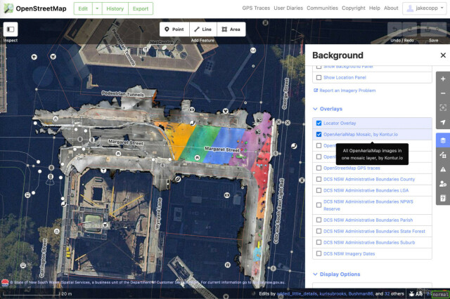
Generating aerial imagery with your iPhone’s LiDAR sensor - Jake Coppinger
This technical guide details how you can create your own aerial imagery and 3D models of streets with the built in iPhone LiDAR sensor and open source tools in the OpenDroneMap package.https://jakecoppinger.com/author/jakcop_t1chd5/#author (Jake Coppinger)
👥 Contributeur/ices : GuilhemAllaman, @Data_Wax
, @aurelienchaumet , @dmontagne
, @GabPoujol , @geojulien , Maël Reboux
🌍 #LIDAR, #geOrchestra, #ANFR, @ThomasG77, #Copernicus, #wikipedia

Geotribu - Revue de presse du 17 février 2023
De l'espace au terrain, la terre continue d'être cartographiée sous toutes les coutures.Geotribu
New #lidar dataset for Guadalajara city. 2019 flight now available in #laz format at
https://lidar.guadalajara.gob.mx