Search
Items tagged with: opendronemap
My own #3DTiles generated in #WebODM on the new #QGIS  3.34 #Prizren #GIS 🗺
#drones #mavic3 #Guadalajara #photogrammetry #structurefrommotion #SfM #odm #opendronemap #CesiumJS
3.34 #Prizren #GIS 🗺
#drones #mavic3 #Guadalajara #photogrammetry #structurefrommotion #SfM #odm #opendronemap #CesiumJS
3.34 #Prizren #GIS 🗺
#drones #mavic3 #Guadalajara #photogrammetry #structurefrommotion #SfM #odm #opendronemap #CesiumJS

Tomorrow at the University of Guanajuato, within the "Engineering Week" event, I will be presenting, as part of the Official QGIS Mexico User Group , the #GIS  of the Government of #Guadalajara 🇲🇽 done in the last two years of work (Only the new developments)
Using #FOSS geospatial
#QGIS #Potree #PostGIS #Geoserver #Leaflet #OpenDroneMap #WebODM #WhiteboxTools #Lastools #CloudCompare #GeoSAM
For #LiDAR #webmapping #drones #photogrammetry #cadastral #survey #AI #mobility
, the #GIS of the Government of #Guadalajara 🇲🇽 done in the last two years of work (Only the new developments)Using #FOSS geospatial
#QGIS #Potree #PostGIS #Geoserver #Leaflet #OpenDroneMap #WebODM #WhiteboxTools #Lastools #CloudCompare #GeoSAM
For #LiDAR #webmapping #drones #photogrammetry #cadastral #survey #AI #mobility
Yoooo, I'm pretty much the worst person in the world at what I do, so please follow the friendly OpenDroneMapUpdatesBot account for helping you to keep tabs on when we update stuff to stable releases/tags!
Hey, I'm only a few months behind 🤣
https://botsin.space/@OpenDroneMapUpdatesBot
#OpenDroneMap #ODMUpdatesBot
@OpenDroneMapUpdatesBot
Hey, I'm only a few months behind 🤣
https://botsin.space/@OpenDroneMapUpdatesBot
#OpenDroneMap #ODMUpdatesBot
@OpenDroneMapUpdatesBot
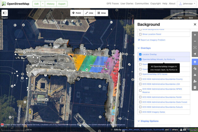
I wrote a technical guide on how you can create your own aerial imagery and 3D models of streets with the built in iPhone LiDAR sensor and open source tools in the OpenDroneMap package.
I've found you can attach your iPhone to your bike and generate LiDAR point clouds of the kerb and cycleway infrastructure if you go slow!
https://jakecoppinger.com/2023/03/generating-aerial-imagery-with-your-iphones-lidar-sensor/
#lidar #openstreetmap #maps #iphone #openaerialmap #cycling #infrastructure #urbanism #sydney #australia #betterstreets #opendronemap #odm #webodm
Generating aerial imagery with your iPhone’s LiDAR sensor - Jake Coppinger
This technical guide details how you can create your own aerial imagery and 3D models of streets with the built in iPhone LiDAR sensor and open source tools in the OpenDroneMap package.https://jakecoppinger.com/author/jakcop_t1chd5/#author (Jake Coppinger)